Population Growth
Algeria Total Population Growth in the 1960s (1960-1969)
Algeria Total Population Growth in the 1960s
This page reviews Algeria total population growth in the 1960s. Algeria’s official name is the People’s Democratic Republic of Algeria. It is located on the north-western coast of Africa. Algeria borders the following countries; to the southwest by Mali , northeast by Tunisia , to the southeast by Niger , Mauritania , and Western Sahara, to the east by Libya ; and to the west by Morocco . Algeria gained independence from France on July 5, 1962.
The below chart and review shows the Algeria total population growth in the 1960s from 1960-1969 during the decade of its independence movement. Click here to review Algeria’s country overview.
Chart of Algeria Population Growth in the 1960s (1960-1969)
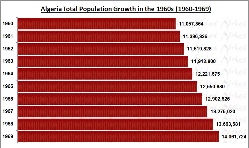
Bar chart of Algeria population growth from 1960 to 1969.
Conclusion
Algeria’s population between 1960-1969 increased steadily for the decade. The population grew from 8.8 million people in 1960 to 10.7 million people in 1969. As a result, the population grew an impressive 21% in the 1960s (1960-1969).
Algeria’s population has grown over the years and decades. Furthermore, as more people are born and others live longer, the population will grow. This is wonderful, but it means the country must plan for things like schools and hospitals and increase jobs. Additionally, Algeria wants to make sure everyone has a good life. As the population keeps growing, the country will keep working to make sure everyone is happy and has what they need. It’s like taking care of a big family to help them all live well together. Algeria’s task of population growth is mainly about taking care of people and making sure there is a prosperous future.
To conclude, Algeria has similar economic and security challenges as most countries on the African continent but still managed to maintain sustained population growth. Click here for Algeria’s population growth in the 1970s.