Population Growth
Mali Population Growth in the 1950s (1950 to 1959)
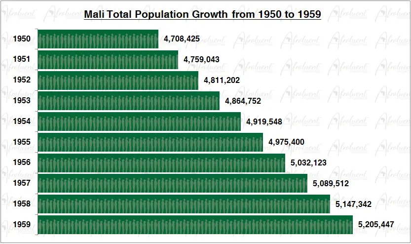
Mali Population Growth from 1950 to 1959
This page shows Mali population growth in the 1950s from 1950 to 1959. Mali’s official name is the Republic of Mali. The country is located in the northwest of Africa. Additionally, it borders west of Niger, southwest of Algeria, north of Guinea, Cote d’Ivoire, and Burkina Faso. Eventually, Mali declared independence on September 22, 1960.
The chart and review show the total population growth of Mali from 1950 to 1959. Furthermore, this was the decade before Mali’s independence in 1960. Click here to review Mali country overview.
Chart of Mali Population Growth in the 1950s (1950 to 1959)
**Bar chart data are medium statistical estimates.
Conclusion
Mali’s population grew steadily from 1950 to 1959 for the decade. The population grew from 4.7 million people in 1950 to 5.2 million people in 1959. As a result, the population grew by 10.6% in the 1950s (1950 to 1959). Additionally, the total life expectancy in Mali is approximately 59.3 years (2019). Lastly, around 44% of Mali’s population lives in urban areas.
Most importantly, the life expectancy in Mali has increased from 28.1 years in 1960 to 59.3 years in 2019. To conclude, Mali maintained sustained population growth despite having similar challenges as most countries on the African continent. Click here for Mali’s population growth in the 1960s.