Population Growth
Côte d’Ivoire Population Growth in the 1960s (1960 to 1969)
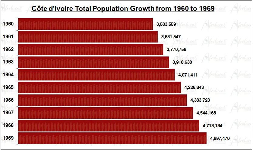
Côte d’Ivoire Population Growth from 1960 to 1969
This page shows Côte d’Ivoire population growth in the 1960s from 1960 to 1969. Its official name is the Republic of the Côte d’Ivoire. The country is located on the southern coast of West Africa. Additionally, it borders Liberia to the west, Burkina Faso to the northeast, Ghana to the east, Mali to the northwest, and Guinea to the northwest. Eventually, Côte d’Ivoire regained independence from France on August 7th, 1960.
The chart and review show the total population growth of Côte d’Ivoire from 1960 to 1969. Furthermore, this was the decade during Côte d’Ivoire’s independence in 1960. Click here to review Côte d’Ivoire country overview.
Chart of Côte d’Ivoire Population Growth in the 1960s (1960 to 1969)
**Bar chart data are medium statistical estimates.
Conclusion
Côte d’Ivoire’s population grew steadily from 1960 to 1969 for the decade. The population grew from 3.5 million people in 1960 to 4.9 million people in 1969. As a result, the population grew by 40% in the 1960s (1960 to 1969). Additionally, the total life expectancy for Côte d’Ivoire is approximately 57.7 years (2020). Lastly, the country is among the smallest on the African continent, but its population has rapid growth.
Most importantly, the life expectancy in Côte d’Ivoire has increased from 36.1 years in 1960 to 57.7 years in 2020. To conclude, Côte d’Ivoire maintained sustained population growth despite having similar challenges as most countries on the African continent. Click here for Côte d’Ivoire’s population growth in the 1970s.