Population Growth
Guinea Population Growth in the 1960s (1960 to 1969)
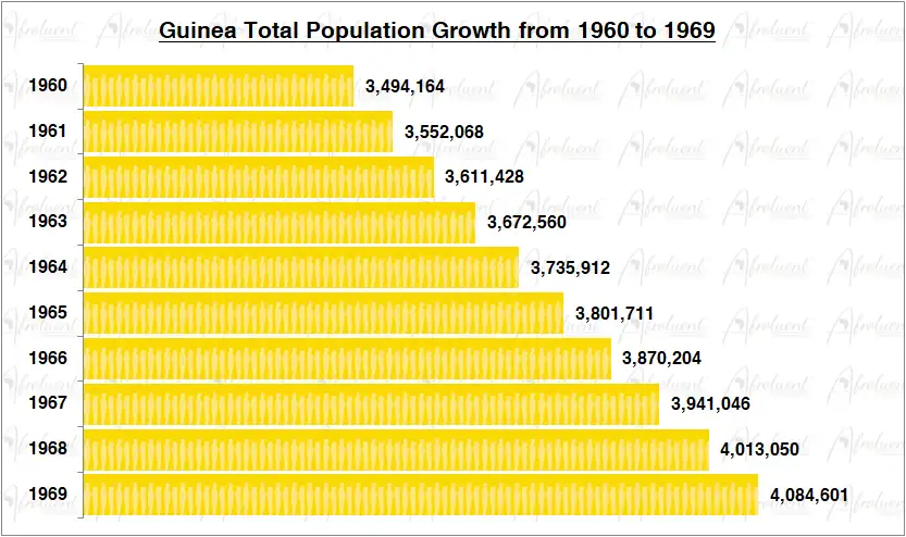
Guinea Population Growth from 1960 to 1969
This page shows Guinea population growth in the 1960s from 1960 to 1969. Guinea’s official name is the Republic of Guinea. The country is located on the west coast of Africa. Additionally, it borders Liberia to the south, Ivory Coast to the east, Senegal to the north, Mali to the north-east, Sierra Leone to the south-west, and Guinea-Bissau to the north-west. Eventually, Guinea gained independence from France on October 2nd, 1958.
The chart and review show the total population growth of Guinea from 1960 to 1969. Furthermore, this was the decade after Guinea’s independence in 1958. Click here to review Guinea country overview.
Chart of Guinea Population Growth in the 1960s (1960 to 1969)
**Bar chart data are medium statistical estimates.
Conclusion
Guinea’s population grew steadily from 1960 to 1969 for the decade. The population grew from 3.4 million people in 1960 to 4 million people in 1969. As a result, the population grew by 17.6% in the 1960s (1960 to 1969). Additionally, the total life expectancy for Guinea is approximately 61.6 years (2019). Lastly, most of Guinea’s population lives in rural areas.
Most importantly, the life expectancy in Guinea has increased from 36 years in 1960 to 61.6 years in 2019. To conclude, Guinea maintained sustained population growth despite having similar challenges as most countries on the African continent. Click here for Guinea’s population growth in the 1970s.