Population Growth
Malawi Population Growth in the 1960s (1960 to 1969)
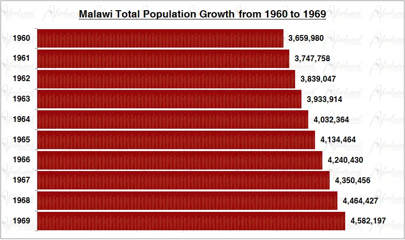
Malawi Population Growth from 1960 to 1969
This page shows Malawi population growth in the 1960s from 1960 to 1969. Malawi’s official name is the Republic of Malawi. The country is located in the southeast of Africa. Additionally, it borders Mozambique to the east and south, Zambia to the west, and Tanzania to the north. Eventually, Malawi declared independence on July 6th, 1964.
The chart and review show the total population growth of Malawi from 1960 to 1969. Furthermore, this was the decade during Malawi’s independence in 1964. Click here to review Malawi country overview.
Chart of Malawi Population Growth in the 1960s (1960 to 1969)
**Bar chart data are medium statistical estimates.
Conclusion
Malawi’s population grew steadily from 1960 to 1969 for the decade. The population grew from 3.6 million people in 1960 to 4.5 million people in 1969. As a result, the population grew by 25% in the 1960s (1960 to 1969). Additionally, the total life expectancy in Malawi is approximately 64.2 years (2019). Lastly, around 18% of Malawi’s population lives in urban areas.
Most importantly, the life expectancy in Malawi has increased from 36.6 years in 1960 to 64.2 years in 2019. To conclude, Malawi maintained sustained population growth despite having similar challenges as most countries on the African continent. Click here for Malawi’s population growth in the 1970s.