Population Growth
Zambia Population Growth in the 2000s (2000 to 2009)
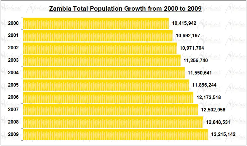
Zambia Population Growth from 2000 to 2009
This page shows Zambia’s population growth in the 2000s from 2000 to 2009. Zambia’s official name is the Republic of Zambia. The country is located in the southeast of the continent of Africa. Additionally, it borders; Angola to the west, Tanzania to the north-east, Malawi to the east, Zimbabwe and Botswana to the south, Mozambique to the southeast, Namibia to the southwest, and the Democratic Republic of the Congo to the north. Eventually, Zambia declared independence on October 24th, 1964.
The chart and review show the total population growth of Zambia from 2000 to 2009. Furthermore, this was four decades after Zambia’s independence in 1964. Click here to review Zambia country overview.
Chart of Zambia Population Growth in the 2000s (2000 to 2009)
**Bar chart data are medium statistical estimates.
Conclusion
Throughout the decade from 2000 to 2009, Zambia’s population increased gradually. From 10.4 million in 2000 to 13.2 million in 2009, the population increased. As a result, between 2000 and 2009, the population increased by 26.9%. Furthermore, as of 2019, Zambia’s overall life expectancy is roughly 64.1 years. Last but not least, almost 45% of Zambians reside in cities.
In conclusion, while facing many of the very same difficulties as the majority of African nations, Zambia managed to continue population growth.
Click here for Zambia’s population growth in the 2010s.